
18 Dec Extreme fire danger warning issued for parts of South Africa
- An extreme fire danger warning has been issued for parts of South Africa
- Authorities caution that conditions over the next several days could spread the fire
- An analysis also indicates that wildfires could be present due to extreme heat and dry vegetation
An extreme fire danger warning has been issued for parts of South Africa, with authorities cautioning that conditions over the next several days could lead to rapid fire ignition and spread.
Environmental risk analysis by Mitkat Advisory indicates a heightened threat from wildfires stemming from extreme heat, dry vegetation, strong winds and human ignition sources.
Summer fire seasons are a recurring risk in South Africa, particularly in December, when hot, dry and windy conditions combine to accelerate fire behaviour, making it a hot spot for fires to erupt.
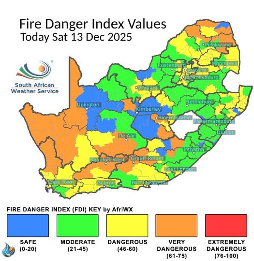
The warning primarily applies to parts of the Eastern Cape, Northern Cape, and Western Cape, with the highest risk expected over a 24- to 72-hour period, particularly during peak daytime temperatures and afternoon wind surges, per the South African Weather Service (SAWS).
High-risk areas include fire-prone corridors in the Western Cape, such as the Cape Winelands, including Stellenbosch, Paarl and Franschhoek, as well as the Witzenberg Municipality. Then there is also an elevated risk expected in the Karoo interior near Beaufort West and Prince Albert, and in wildland–urban interface zones bordering fynbos and renosterveld vegetation.
Medium-risk areas include semi-arid districts of the Northern Cape, where dry scrub and strong winds are common, and rural parts of the Eastern Cape characterised by mixed agricultural land and grassland. Densely built urban areas, however, are considered lower risk due to limited fuel load, although smoke exposure and power disruptions remain possible, per the risk group.
Authorities have since warned that fast-moving fires could lead to evacuations, road closures and disruptions to power and water infrastructure.
They also shared how transport routes, including sections of the N1, N2 and R62, may be closed at short notice during firefighting operations.
During this time, smoke is expected to reduce visibility, affecting road safety and limited aviation activity. Fires may also damage agricultural land, tourism facilities and essential services, with broader knock-on effects for regional supply chains.
Organisations and communities in high-risk areas are advised to suspend non-essential hot works, enforce strict controls on ignition sources and pre-position firefighting resources, water supplies and backup power. Travel restrictions and evacuation plans have been suggested to be reviewed, particularly for staff working in exposed locations.
Ongoing coordination with WeatherSA, municipal fire services and disaster management centres is recommended, per the risk group, as they advise that critical assets, including fuel storage and overhead power infrastructure, should be secured where possible, and business continuity plans should be activated to allow for remote operations or alternative logistics routes if required.
The team explained how the trajectory of the threat will depend largely on wind conditions and the number of ignition sources over the coming days.
However, authorities stress that early preparedness, strict fire controls and continuous monitoring will be essential to reduce the impact on communities, infrastructure and the economy.
Sorry, the comment form is closed at this time.